-
 A stationary front increases rain coverage across parts of Florida through the end of this week, while a high-pressure system builds just in time for the weekend, bringing temperatures near record heat or breaking records.
 -
 Florida officially entered astronomical summer on June 21, marking the longest day of the year.
 -
 On Thursday, temperatures were already hot across much of the Florida Peninsula, with roughly two-thirds of the state under a Heat Advisory. Not only were air temperatures high, but the combination of heat and humidity pushed heat index values as high as 110°F in some locations.
 -
 Tropical storm Arthur was short lived, lasting only about 6 hours. But forecasters are watching for increased flooding rain and storm chances across parts of Florida later this week.
 -
 Arthur became the first named system of the season, but in less than 6 hours after being named, it moved over land in Texas. The flash flood threat continues for the next couple of days across the Southeast.
 -
 Heavy rains threaten the Gulf Coast states, from Southeast Texas through the Deep South. Heavy rains could affect parts of the western Florida Panhandle.
 -
 Florida is known for its sunshine and heat, but the state’s hottest air temperature is actually lower than nearly every other state.
 -
 A lower-category storm can still be deadly, and the kind of danger a hurricane brings often depends on which part of the state is in its path.
 -
 Dangerous heat is coming to North Florida and the Panhandle this weekend; the heat risk moves south next week.
 -
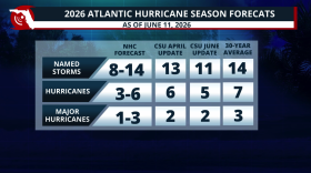 Colorado State lowers its 2026 Hurricane Season forecast due to a strong El Niño developing during the season. What does this mean?

© 2026 | WUWF Public Media
11000 University Parkway
Pensacola, FL 32514
850 474-2787
11000 University Parkway
Pensacola, FL 32514
850 474-2787
Play Live Radio
Next Up:
0:00
0:00
Available On Air Stations


